Path planning#
IR-SIM includes grid- and sampling-based path planners for computing a collision-free path on an occupancy map. Planners are used programmatically: you build a map from the world, plan a path from the robot’s state to its goal, and (optionally) let the robot follow it with a dash behavior or your own controller.
Overview#
Every planner follows the same four-step workflow:
Build the map:
env.get_map(resolution=...)returns the occupancy grid the planner searches (resolutionis the planning cell size in meters).Create the planner: instantiate one planner from
irsim.lib.path_planners.Plan:
planner.planning(start, goal)returns a trajectory (list of[x, y]points), orNoneif no path is found.Draw / follow:
env.draw_trajectory(trajectory)overlays the path; feed it to a controller to follow it.
The start and goal come from the scene: env.get_robot_state() and env.get_robot_info().goal.
Supported algorithms#
Planner |
Import from |
Type |
Use when |
|---|---|---|---|
A* |
|
grid, 8-neighbour |
you want a fast, optimal grid path |
JPS |
|
grid (optimised A*) |
same paths as A*, faster on open grids |
RRT |
|
sampling |
non-grid / Shapely obstacles; a feasible (not optimal) path |
RRT* |
|
sampling |
shorter, optimised paths via rewiring |
Informed RRT* |
|
sampling |
faster convergence to the optimum after a first solution |
PRM |
|
sampling roadmap |
many queries against the same static map |
Grid planners (A*, JPS) and PRM search the grid occupancy from obstacle_map; RRT / RRT* / Informed RRT* can use the same grid or Shapely obstacle geometry.
Quick example#
Plan an A* path on a Perlin-noise grid and draw it. Pass show_animation=True to watch the search expand live.
import irsim
from irsim.lib.path_planners import AStarPlanner

env = irsim.make("path_planning.yaml", save_ani=False, full=False)

# 1. occupancy grid from the world's obstacle_map
env_map = env.get_map(resolution=0.2)

# 2. planner
planner = AStarPlanner(env_map)

# 3. plan from the robot's state to its goal
robot_state = env.get_robot_state()
goal_xy = env.get_robot_info().goal[:2, 0].tolist()
trajectory = planner.planning(robot_state, goal_xy, show_animation=True)

# 4. draw the path as a red line
if trajectory is not None:
    env.draw_trajectory(trajectory, traj_type="r-")

env.end(5)
world:
  height: 20
  width: 30
  step_time: 0.1
  obstacle_map:           # procedural occupancy grid, built at load time
    name: perlin
    resolution: 0.1
    complexity: 0.08
    fill: 0.15
    fractal: 1
    attenuation: 0.5
    seed: 56

robot:
  - kinematics: {name: 'diff'}
    shape: {name: 'circle', radius: 0.2}
    state: [2, 2, 0]
    goal: [24, 16, 0]
    behavior: {name: 'dash'}
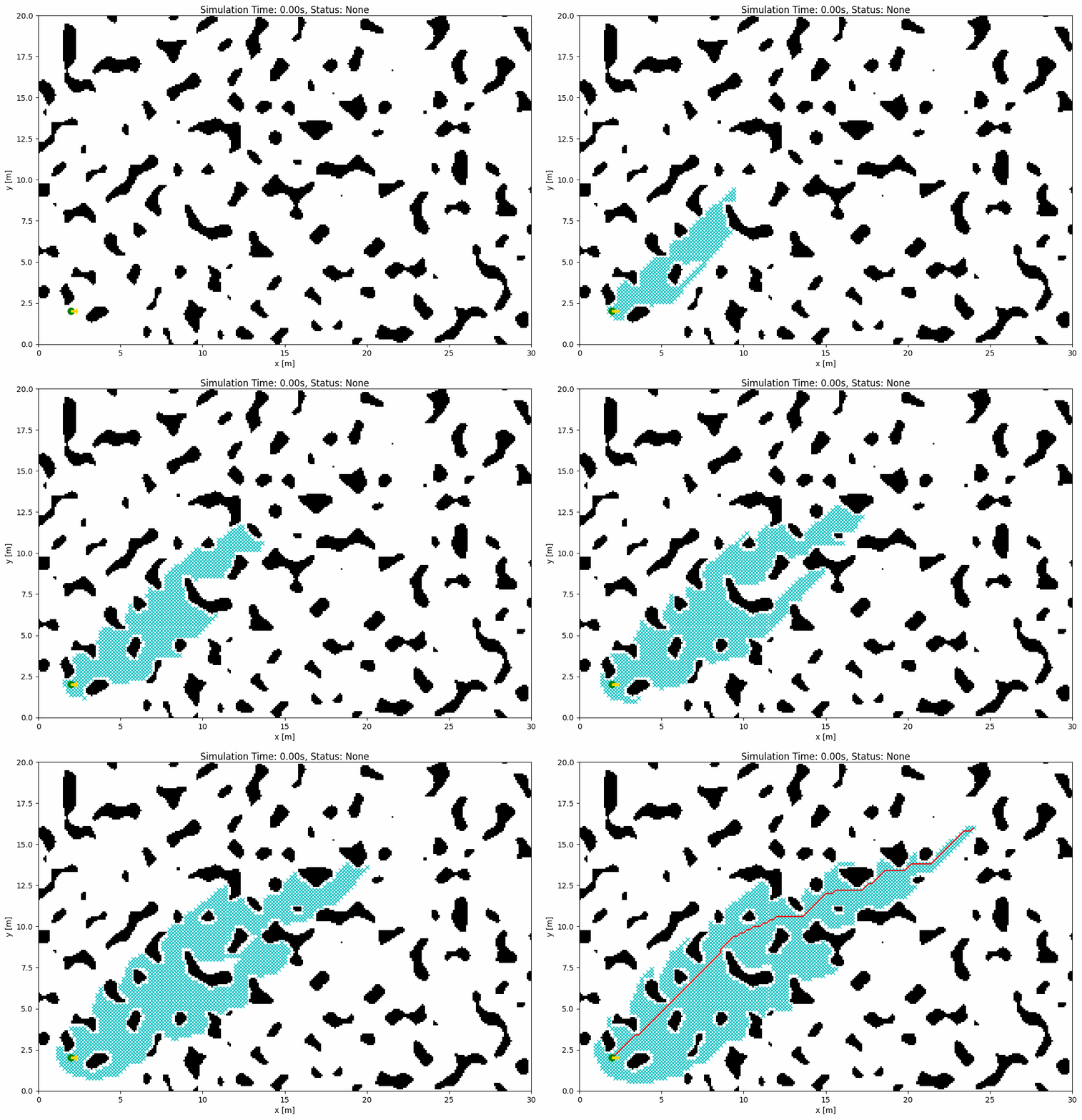
Swap AStarPlanner for any other planner: only the constructor changes; planning() and draw_trajectory() stay the same.
Planner constructors#
The first argument is always the map; sampling planners also take the robot (for collision radius) and tuning parameters.
from irsim.lib.path_planners import (
    AStarPlanner, JPSPlanner, RRT, RRTStar, InformedRRTStar, PRMPlanner,
)

env_map = env.get_map(resolution=0.2)   # 0.1 is typical for the RRT family

AStarPlanner(env_map)
JPSPlanner(env_map)
RRT(env_map, robot=env.robot, expand_dis=1.5, max_iter=5000)
RRTStar(env_map, robot=env.robot, expand_dis=1.5, max_iter=5000)
InformedRRTStar(env_map, robot=env.robot, expand_dis=1.5, max_iter=5000)
PRMPlanner(env_map, robot_radius=env.robot.radius, n_sample=500, n_knn=10)
planning(start, goal, show_animation=False) returns a list of [x, y] points or None. For the sampling planners, planner.end.cost and len(planner.node_list) report the path cost and tree size.
Runnable examples#
Scripts under usage/20path_planning run every planner on the shared path_planning.yaml:
Script |
Planner |
|---|---|
|
A* |
|
Jump Point Search |
|
RRT |
|
RRT* |
|
Informed RRT* |
|
PRM |
See the irsim.lib.path_planners section of the API Reference for the full planner API.